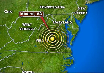
Earthquake Lights Up Chyron’s Cloud-Based Axis System

Image courtesy WCSH
MELVILLE, N.Y.: Immediately following the 5.8 magnitude earthquake shook the East Coast Aug. 23, newsrooms across the United States used Chyron’s cloud-based Axis World Graphics system for instant creation of maps for breaking news segments, the vendor said.
Within minutes of the quake, Chyron said Axis World Graphics users created 15 maps illustrating activity, and within an hour, the total of static and animated maps created grew to 62. By 6 p.m. EDT, just over four hours after the earthquake struck, users had created 98 earthquake-related maps in Axis World Graphics, and by 10:30 p.m. EDT the graphics total reached 133.
The professional video industry's #1 source for news, trends and product and tech information. Sign up below.
