Weather Forecasts Zoom in on Local

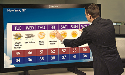
Accuweather Storyteller recently updated its StoryTeller interactive touchscreen system that allows stations to offer highly-visible hourly forecasts while being fully adaptable to most existing broadcast workflow systems.
ALEXANDRIA, VA.—As technology continues to make the world a smaller place, the concept of local has increasingly changed. While weather forecasts for a city’s metro area were once considered about as local as it could get, the latest advances in broadcast weather graphics, along with apps for mobile devices have made local weather a very personalized experience.
This comes as weather graphics have become more interactive, as social media services including Facebook and Twitter allow viewers to relay information at such a local level that it could now be dubbed “hyper local.”
APPS DELIVER LOCAL
“The most important advances we have seen is that we can better connect with our viewers and provide a local and even hyper local experience and bring people that information on a regular day,” said Eric Valadez, executive producer at WFAA-TV in Dallas-Fort Worth. “To be able to use social media and send the weather graphics out via Twitter allows us to connect with viewers in ways that weren’t possible before.”
Local has become all the more important to TV weather graphics providers including Accu-Weather, Baron Services, WSI and Weather Central, especially as viewers have so many more options today—including a plethora of websites.
“Local has always been important,” said Mike Mougey, vice president of sales at Baron Services in Huntsville, Ala. “Stations have identified local as a key component of the newscast.” Relaying up-to-date information to the viewer remains crucial, but conveying the information is what really matters. “We’ve got systems that allow us to create graphics that are driven by weather, and we spend a lot of time analyzing the weather reports from the national weather service radars,” Mougey continues. “If you can have an accurate depiction through the use of these graphics the viewer can better understand and the meteorologist can convey this better.”
GOING TO EXTREMES
Nowhere is the use of weather graphics more important than in times of extreme conditions, and those at the forefront of forecasts have noted that a fine line exists between informing the viewer in a way where the severity is emphasized and creating a potential panic.
Get the TV Tech Newsletter
The professional video industry's #1 source for news, trends and product and tech information. Sign up below.
“The ‘sky is falling’ syndrome is way overdone these days,” Dave Brown, station chief at WMC-TV in Memphis noted. “Over warning is a great danger. Viewers don’t pay attention the 13th time as you create a boy who cried wolf scenario. This is where the weather graphics really have allowed us to better define what a severe thunderstorm is compared to say, just a thunderstorm with some heavy wind gusts.”
Recently, AccuWeather in State College, Pa., updated its StoryTeller interactive touchscreen system that allows stations to offer highly-visible hourly forecasts while being fully adaptable to most existing broadcast workflow systems. This, coupled with its audience-generated social media content help ensure that severe weather can be reported at that hyper-local level.
“We take local a step further and can bring up radar and highlight the areas that might be most affected during severe weather,” Ryan Ayres, vice president of AccuWeather’s Display Systems and Services division. In addition, while local used to mean a station’s viewing area, which could be a large swath, AccuWeather can provide forecasts by individual zip codes. “That is very local, and it is important because weather can vary very much across town.”
HD GRAPHICS

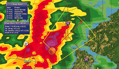
Baron Services’ FasTrac graphics package shows a shear marker (circle) and a SCIT (Storm Cell Identification Track) which indicates the direction that that part of the storm is moving. Just as social media is providing greater interaction for viewers, the improvements in high-definition graphics has also improved the overall experience. “The difference from standard definition to high definition has been pretty significant, and weather graphics are a big part of this,” added WMC-TV’s Brown. “Graphics that don’t look good simply aren’t acceptable to the viewers.”
HDTV can also show what simply wasn’t possible in standard definition.
“The whole advent of HDTV has made it so that graphics can be rich and full-featured,” said Jim Brihan, director, media product management at WSI-Weather Central. “To help cover severe weather such as tornados we’ve created 3D graphics that help display the formation, and can superimpose the area where debris can be picked up and fly into the air.”
This is important as in extreme weather it isn’t just the storm that can be dangerous but the debris that is picked up. This debris can have a different radar signature, and WSI’s technology can help see this signature as it moves. Staying ahead of a storm is also something that today’s advanced systems can do better than ever.
“In terms of tropical coverage we can display information from aircraft in real time,” added Brihan. “It is the most up to date information and can come out even before the hurricane service has the information.”
However, in the end it still comes back to providing that information to those who may be in harm’s way, and the local story thus can’t be understated.
“A lot of severe weather fatalities occur despite the fact that there was a warning in place,” added AccuWeather’s Ayres. “StoryTeller can provide views from the field, and people can tell that this isn’t just a watch but that bad things are unfortunately happening.”
